
It seems pretty obvious that high-intensity fires destroy the land, but an ecologist named Dirac Twidwell from The University of Nebraska wants to change that.
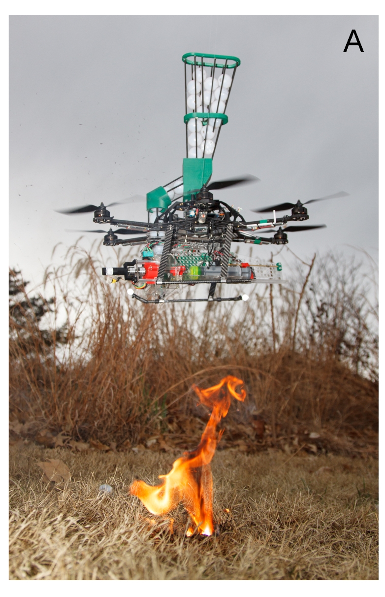
According to Twidwell, extreme fire can be harnessed to restore grasslands on the Great Plains. To create extreme fires, he’s recruited the help of a small drone that can launch “dragon eggs” of fire about the size of a ping-pong ball to do it safely and inexpensively.
Twidell developed the two-pound drone with the help of Nebraska Intelligent MoBile Unmanned Systems (NIMBUS) Lab, in order to aid in wildfire suppression as well as to ignite prescribed burns for management of wildlands and rangeland.
“Nobody is really studying high intensity fire, because everyone would think you are crazy. We have always been told that high intensity fires during drought are bad. That’s the problem: we have been studying fire when we were told it is OK to ignite and control fires on landscapes. To me, it’s a job for scientists to do. If we are going to understand the role of fire in nature, we need to study a bigger range of intensities, and we need new approaches to do it,” said Twidwell.
The argument for fire
According to the ecologist, it was fire that initially shaped the prairie ecosystem of the Great Plains. Fires that were naturally ignited by lightning would sweep through and kill off the seedlings of trees and shrubs and promote the dominance of fast-germinating native grasses, which adapt to frequent fire. Fire releases nutrients that fuel more vibrant regrowth, a pattern recognized by native peoples who set grass fires to improve browse for buffalo. By successfully minimizing the fires that occur in this area, the woody shrubs like juniper gain a stubborn foothold and the entire Great Plains’ grass sea is about to become nothing but shrubs.
“We used to say we couldn’t kill juniper after they grew to about 6 feet. That belief really effected policy. It’s not true,” said Twidwell.
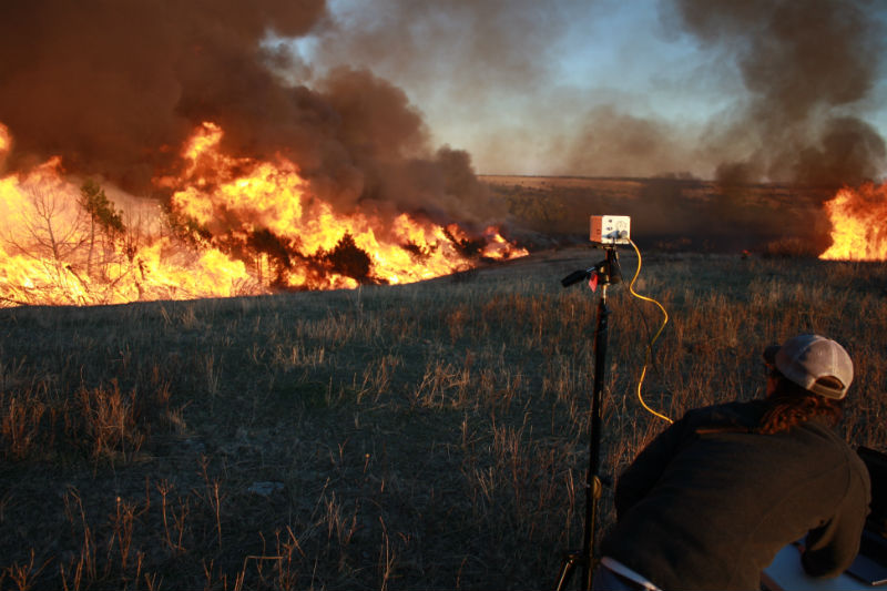
The real problem is that low-intensity burns that groups try to create to combat this do not mimic the natural fire conditions. These usually take place in mild weather conditions when temperatures are cool, winds are gentle and steady, humidity is moderate, and soil and fuels are moist with recent rain. But more fires burned when the weather was hot, during drought or when winds were high.
He conducted experimental high-intensity burns in Texas at a humid subtropical site near Corpus Christi and a semi-arid site on the Edwards Plateau. In testing, intense fire burned through the juniper canopy. Further experiments demonstrated that grass recovers quickly after extreme fire.
“In grasslands of the Great Plains, fire is a stabilizing force,” said Twidwell.
Keeping the fire contained
In order to prevent experimental fires from running wild, Twidwell and his team calculated the maximum distance embers could jump to kindle a new fire based on ember transport models used in forest fire fighting. They created firebreaks much larger than that distance, about the size of five football wide.
Drones are playing a great role in this aspect of nature. Their electo-optical camera eyes allow pilots to peer through smoke that human eyes can’t penetrate, measure heat intensity, and locate natural fire breaks and water resources. Drones can be fitted with air quality and weather monitoring equipment and carry radio relays or cellular transmission into remote areas where service is spotty.
In addition, round-the-clock drone monitoring of the California Rim Fire in 2013 helped firefighters map the spread of the fire, taking the load off of helicopter pilots.
Unmanned aerial craft also have great potential to help scientists learn about wildfires in action by tracking fires as they burn across a landscape and collecting data that would be difficult to obtain from the ground.
“In grassland ecosystems we are really data-poor in terms of fire behavior. We need finer scale spatial data and a lot of it to understand the effects of fire on ecosystems and we just haven’t had the technology to capture it,” said Twidwell. “Understanding the spatial context and intensity of fires matters whether your goal is to protect a house or restore a grassland ecosystem.”
Using their prototype fire-yielding drone Twidwell and his team conducted two field trials in Nebraska.
“They managed the boundary and let us do drops in the interior to test the technology. It was small, about 20 acres, and a nice opportunity, in a controlled setting, to work together testing the idea.”
The operators from the NIMBUS lab are licensed pilots and obtained authorization to conduct the test flights and burns. They flew the prototype within 100 meters and in sight of the pilot for the ignition experiments, in part due to Federal Aviation Administration regulations.
According to Twidwell, there are already requests from private landowners and agency land managers who want their own drone.
Twidwell cautions that others should not take it upon themselves to create fires.
Comments are closed, but trackbacks and pingbacks are open.