

Infrastructure in the already-developed world is an increasing drain on municipal revenues as municipal governments struggle to identify, maintain, and repair infrastructure to ensure their citizens’ safety. Now there’s a program that monitors street signs needing replacement or repair via Google Street View. The fully automated system is trained using AI-powered object detection to identify street signs.
Municipal authorities currently spend large amounts of time and money monitoring and recording the geolocation of traffic infrastructure manually, a task which also exposes workers to unnecessary traffic risks.
Results just published in the Journal of Computers, Environment and Urban Systems show the system detects signs with near 96% accuracy, identifies their type with near 98% accuracy and can record their precise geolocation from the 2D images.
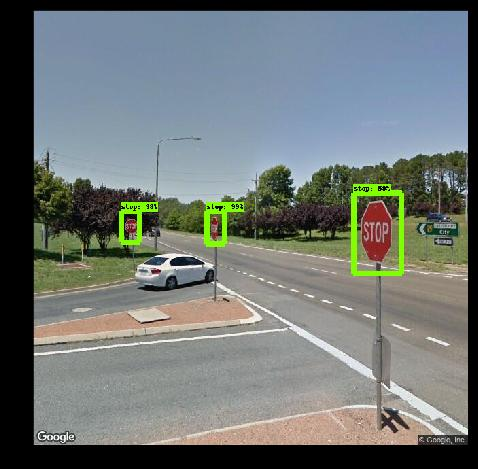
(Image Credit: RMIT University)
Study lead author and RMIT University Geospatial Science Honours student Andrew Campbell said the proof-of-concept model was trained to see stop and yield signs but could be trained to identify many other inputs and was easily scalable for use by local governments and traffic authorities.
“(Municipal authorities) have requirements to monitor this infrastructure but currently, no cheap or efficient way to do so,” Campbell said. “By using free and open source tools, we’ve now developed a fully automated system for doing that job, and doing it more accurately.”
The team found during investigations that mandatory GPS location data in existing street sign databases were often inaccurate, sometimes up to 10m off.
“Tracking these signs manually by people who may not be trained geoscientists introduces human error into the database. Our system, once set up, can be used by any spatial analyst—you just tell the system which area you want to monitor and it looks after it for you,” Campbell said. The initial concept was designed by Alpine Shire Council and RMIT Geospatial Science alumnus Barrett Higman.
RMIT geospatial scientist and project co-lead, Dr Chayn Sun, said the fact that some councils were already attaching cameras onto rubbish trucks to gather street footage showed how valuable visual data were becoming, given what technology could now do with it.
“This imagery is critical for local governments in monitoring and managing assets and with the huge amount of geospatial applications flourishing, this information will only become more valuable,” Sun said.
“Ours is one of several early applications for this to meet a specific industry need but a whole lot more will emerge in coming years.”
Sun said footage from other sources, like that from rubbish truck cameras or any other geo-referenced imagery of the road network collected by municipal authorities, could also be fed into the system.
“Where footage is already being gathered, our research can provide councils with an economical tool to drive insights and data from this existing resource,” she said.
Source: RMIT University