


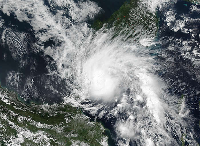
The late-season Tropical Storm Otto is most certainly on its way to Central America, yet satellites are keeping a track of it. NASA-NOAA’s Suomi NPP satellite captured an image of Otto as it was briefly strengthening into a hurricane.
On November 22nd at 2:24pm, the Visible Infrared Imaging Radiometer Suite (VIIRS) instrument aboard the NASA-NOAA Suomi NPP satellite captured a visible image of Otto as it was strengthening into a hurricane in the Caribbean Sea.
Otto was strengthening into a hurricane, yet was not visible quite yet in the VIIRS image.
A Hurricane Warning is in effect for Limon Costa Rica to Bluefields, Nicaragua. A Hurricane Watch is in effect from north of Bluefields to Sandy Bay Sirpi, Nicaragua and south of Limon to the Costa Rica/Panama border.
In addition, a Tropical Storm Warning is in effect from north of Bluefields to Sandy Bay Sirpi, Nicaragua and San Andres. A Tropical Storm Watch is in effect from west of Colon, Panama to the Costa Rica/Panama border and from Puntarenas, Costa Rica to Puerto Sandino, Nicaragua.
Then at 4:00pm the same day, Tropical Storm Otto strengthened into the seventh hurricane of the Atlantic Ocean Hurricane Season when maximum sustained winds reached 75mph (120kph). Otto maintained that strength until 15 hours later at 7am on November 23rd when it weakened to a tropical storm.
The National Hurricane Center said: “Air Force Reserve reconnaissance mission reported that the eyewall has dissipated, along with a 6millibar rise in pressure.”
By 10am, the center of Tropical Storm Otto was located near latitude 11.1 north and longitude 80.7 west. That’s about 175miles (280km) east-northeast of Limon, Costa Rica and 220miles (350km) east-southeast of Bluefields, Nicaragua. The estimated minimum central pressure is 994millibars.
Otto was moving toward the west-northwest near 5mph (7kph) and NHC said a turn toward the west with an increase in forward speed is expected tonight and Thursday. On the forecast track, the center of Otto will move onshore within the hurricane warning area on Thursday, and reach the Pacific coast of southern Nicaragua or northern Costa Rica early Friday.
Maximum sustained winds remain near 70mph (110kph) with higher gusts.
Otto is forecast to become a hurricane again on November 24th (today) before weakening over Central America after landfall.
More information: EurekAlert!